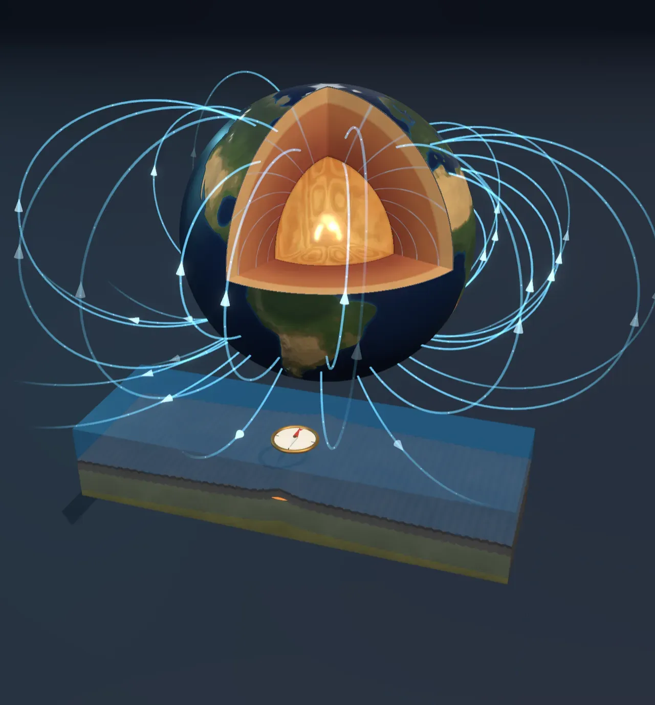
A magnet you can’t see
Hang a magnetised needle so it can turn freely and it settles pointing roughly north. Sailors used that for navigation for about a thousand years, long before anyone knew why it worked. The reason is that the whole Earth is wrapped in a magnetic field. At the surface it is weak, between about 25 and 65 microtesla, a hundred times weaker than a fridge magnet, but it reaches far out into space, where it deflects the solar wind and steers the particles that make auroras.
Near the surface the field looks very like that of a bar magnet whose axis is tilted about ten degrees from the spin axis. Its field lines leave the ground in the southern hemisphere, loop round the planet and come back down in the northern one. A compass needle lines up along them, so its north end points north.
Not a magnet but a dynamo
There is no giant magnet inside the Earth. Iron stops holding any magnetism above about 770 °C, and the deep interior is thousands of degrees hotter. The field is made instead, all the time, in the outer core: a 2,260-kilometre-thick shell of liquid iron and nickel that starts 2,890 km down and surrounds a solid inner core about as hot as the surface of the Sun.
The outer core loses heat into the mantle above it, and as the inner core slowly grows it releases light elements and heat at its edge. Both make the liquid metal rise and sink, like water in a pan. Moving metal in a magnetic field carries electric currents, and electric currents make magnetic fields. Arranged the right way, the flow regenerates the field that steers it, so the field sustains itself. This is the geodynamo. The Earth’s spin twists the flow into swirling columns lined up with the spin axis, which is why the field lines up roughly with the axis too.
Try it: choose Today for Time and look at the floor of the cut-open core. The bands drifting round it are the columns of liquid iron seen end-on.
The field flips
The dynamo is not steady. The magnetic poles wander tens of kilometres a year, and the field’s strength rises and falls. Every so often it does something far more dramatic: it reverses, the north and south magnetic poles swapping places. The last time was about 773,000 years ago. Before that the field was reversed for most of two million years, interrupted by short normal spells such as the Jaramillo and the Olduvai.
During a reversal the main, two-pole part of the field fades to perhaps a tenth of its usual strength. What is left is a tangle of smaller loops with several “north poles” scattered over the globe, and over a few thousand years the main field rebuilds pointing the other way. Reversals come at irregular intervals, from tens of thousands to tens of millions of years apart; nobody can predict the next.
Try it: choose Last flip and watch the long loops collapse into small ones while the compass swings round. Then choose Reversed and compare it with Today: the loops have the same shape, but the arrowheads on them and the compass needle point the other way.
Stripes in the sea floor
How do we know any of this happened? Rocks remember. When lava cools, tiny grains of magnetite in it lock in the direction of the field at that moment, and keep it for millions of years.
Along mid-ocean ridges new sea floor forms all the time, as the plates on either side pull apart and lava fills the gap (see Plate tectonics). Each strip of new rock records the field of its day, then is carried away from the ridge by the spreading. In the late 1950s and early 1960s ships towing magnetometers found the result: long stripes of rock magnetised one way or the other, running parallel to the ridges and mirrored on each side. Read outward from a ridge, they are a tape recording of the field’s reversals, and their widths match the dates of the same reversals found in lava flows on land. That match convinced geologists of two things at once: the field reverses, and the sea floor spreads.
Try it: choose On under Show the magnetic record to drain the sea. Rust stripes formed while the field pointed as it does today; pale ones while it was reversed. The line in the chart beside the Scene is what a ship’s magnetometer would read crossing the ridge: high over rust stripes, low over pale ones. Now drag Time from 3 million years ago towards today and watch the stripes carry outward from the ridge, the newest always matching the compass.
How wide a stripe is depends on how fast the ridge spreads. Each side moves away at half the spreading rate, so a stretch of normal field that lasted a million years leaves a stripe 25 km wide either side of a ridge spreading 5 cm a year, and 70 km wide at 14 cm a year.
Try it: choose Mid-Atlantic under Spreading rate, then East Pacific. The same reversals print narrow stripes on the slow ridge and broad ones on the fast one.
What this model leaves out
The real field is not a dipole plus four small ones; it is measured as hundreds of overlapping patterns, changing year by year. The Scene draws field lines only from the core’s surface outward, though the field inside the liquid core is much stronger and more twisted. The core’s swirling columns follow the pattern that computer models of the geodynamo produce, but here they are a drawn pattern, not a calculation.
Every reversal in the Scene has the same shape: the strength dips for some ten thousand years either side, and the direction swings in a few thousand. Real reversals vary, and some attempts fail: in an excursion, like the Laschamp event about 41,000 years ago, the field weakens and swings briefly before recovering its old direction. Between reversals the model keeps the strength steady, while the real field has varied by about a factor of two.
In the ridge block the stripes have sharp edges; real ones are blurred, because lava cools over a zone kilometres wide and the deeper rock records the field later. The relief and the thickness of the crust are drawn taller than they are, and the sea is far shallower than it would be at that scale.