One water, always moving
Earth has about 1.4 billion cubic kilometres of water, and almost none of it is new. About 97% is salt water in the oceans. Most of the fresh water is frozen in the ice sheets of Antarctica and Greenland, and most of the rest is underground, as groundwater. Lakes, rivers, soil and air hold only a sliver.
The air’s share is the smallest of all, about 13,000 cubic kilometres. If it all fell at once it would cover the planet only 25 mm deep. Yet it is the cycle’s fast lane: the water in the air is replaced, on average, about every nine days. Every day the Sun lifts a vast amount of water out of the sea, and gravity brings the same amount back down. That endless loop is the water cycle.
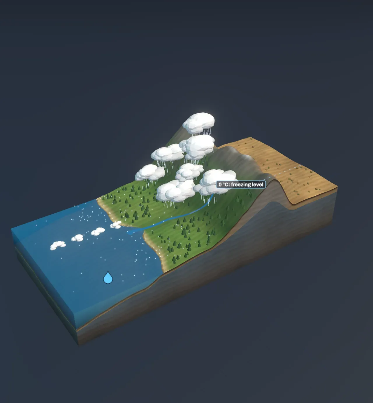
The Scene follows it across one strip of coast: a sea on the left, a coastal plain, a range of mountains and a dry plateau beyond them, with a steady wind blowing in from the sea.
Evaporation: the sea’s invisible export
Water molecules at the surface of the sea are always jostling. Now and then one moves fast enough to break free of its neighbours and escape into the air as a single molecule of water vapour. That is evaporation, the same change of state shown in States of matter, happening far below the boiling point. It takes energy, about 2.5 million joules for every kilogram, and over the ocean that energy comes from sunlight warming the water. The salt stays behind, which is why rain is fresh.
Warmer water evaporates faster, because more of its molecules are moving fast enough to escape. Warmer air can also hold more vapour before it is full, about 7% more for every degree Celsius. Air at 30 °C can hold about five times as much as air at 5 °C. Worldwide about half a million cubic kilometres of water evaporate each year, most of it from the oceans.
Try it: slide Sea temperature down to 4 °C, then up to 28 °C, and watch the vapour dots over the water multiply. In the chart, the blue line moves to the right: air coming off the tropical sea carries almost five times as much vapour, and the sea gives up 4.5 mm of water a day instead of 0.9.
Why rising air makes clouds
The wind carries the vapour inland, low over the plain. When it reaches the mountains the air has nowhere to go but up. Pressure falls with height, so rising air expands, and expanding air cools, by almost 10 °C for every kilometre it rises. Cooler air can hold less vapour. At some height, called the cloud base, the air holds all the vapour it can: it has cooled to its dew point. Above that the extra vapour condenses onto tiny specks of sea salt, dust and smoke, forming droplets about a hundredth of a millimetre across. Billions of them together are a cloud.
Air off a sea at 15 °C that is 80% full of vapour reaches its dew point after rising about 420 m. Above the cloud base it keeps cooling, but more slowly, about 4 to 7 °C per kilometre, because vapour turning back into liquid gives back the heat it took to evaporate.
Try it: step Follow the water to Evaporation, then Cloud. The droplet rides the wind as a dashed ring of vapour and becomes a drop where its air reaches the cloud base. In the chart the blue line climbs straight up to the cloud base, then bends to the left along the dotted line: from there on, the air holds all it can and loses the rest.
From cloud to rain or snow
A cloud droplet is too small to fall. It drifts down about a centimetre a second, and the gentlest rising air holds it up. A raindrop 2 mm across holds as much water as a million cloud droplets, so a cloud has to gather its droplets together before it can rain. In warm clouds they collide and merge. In clouds colder than 0 °C, ice crystals grow while the droplets around them shrink, and the crystals clump into snowflakes heavy enough to fall. If the air below the freezing level is warmer than 0 °C, the snow melts on the way down and lands as rain. Outside the tropics most rain starts as snow.
Try it: slide Sea temperature down to 4 °C. The freezing level drops to about 400 m, almost everything falls as snow, and the followed droplet lands as a snowflake and waits for the thaw. Then slide it up to 28 °C: the freezing level rises far above the highest peak, and it rains right to the summit.
Why the mountains get the rain
The higher the air is pushed, the more it cools and the more water it loses. In the Scene, with a sea at 15 °C, hills 800 m high wring out about 5 mm of rain a day, a coast range 2,500 m high about 25 mm and a high range 4,200 m high about 41 mm, much of it as snow. Mountain ranges facing a moist wind are among the wettest places on Earth.
The far side is a different world. The air that crosses the summit has lost most of its water. As it sinks down the other side it is squeezed and warms by about 10 °C for every kilometre, with no vapour left to condense, so it arrives warm and dry. The land behind the mountains lies in a rain shadow. Jerusalem, on the crest of the Judean hills, gets about 550 mm of rain a year; Ein Gedi, on the shore of the Dead Sea about 35 km to the east and far below the far side of those hills, gets well under 100 mm.
A warmer sea does give more rain, but less than its extra vapour would suggest. Warm saturated air cools more slowly as it rises, because it has more vapour to condense and so more heat to give back. Going from a sea at 15 °C to one at 28 °C more than doubles the vapour but raises the rain on the coast range by only about a quarter. On the high range the air rises far enough to give up much more of it.
Try it: set Height of the mountains to 800 m and then 4,200 m, and compare the shaded gap in the chart. It is the water each kilogram of air loses on its way up to the summit.
Back to the sea
Water that lands on the ground has three ways to go. Some evaporates again, or is drawn up by plants and breathed out through their leaves; on land this takes about three fifths of all the rain and snow. Some soaks into the soil and down to the water table, where it can stay for years or thousands of years. The rest runs off downhill into streams and rivers, carving valleys as it goes. Snow can hold water on the slopes for months and glaciers for centuries, but in the end it melts and follows the rest.
Worldwide, about 40,000 cubic kilometres a year flow back to the sea in rivers and underground. That matches the water the winds carry from the sea onto the land each year, so the cycle balances.
Try it: step Follow the water to Rain or snow and then Runoff, and follow the droplet down the river into the sea, where its journey can begin again.
A warmer cycle
As the climate warms (see Climate), the same rule that governs the Scene applies to the whole planet: each degree lets the air hold about 7% more vapour. More water evaporates, and when air rises and cools it has more to drop, so the heaviest downpours become heavier. At the same time warmer air dries out soil faster between rains, so droughts can bite harder too. Freezing levels rise, more winter precipitation falls as rain instead of snow, and rivers that depend on spring snowmelt run lower in summer. How storms and weather systems carry all this water around is a story of its own.
What this model leaves out
The Scene lifts air only by pushing it over mountains. Most of the world’s rain falls from air lifted where warm and cold air masses meet, at weather fronts, and in thunderstorms, where warm air rises on its own. The wind never changes, the air over the sea always has the sea’s temperature and is always 80% full of vapour, and exactly half of the water that condenses falls on the windward slope while the far side gets none. Real rising air mixes with the drier air around it, real rain spills over the crest, and real snow lines depend on weeks of weather, not just the freezing level of one day’s wind.
The timing is compressed beyond recognition. A water molecule spends about nine days in the air, days to months in a river, years to millennia underground, and on average about 3,000 years in the ocean before it evaporates again. The Scene shows its path, not its pace.