Two ways to wear a mountain down
Mountains look permanent, but every one of them is being taken apart. Two processes do the work, and they almost always work together.
Weathering breaks rock down where it stands: it cracks, crumbles, softens and partly dissolves, without going anywhere. Erosion carries the pieces away: rivers, rain, wind, waves and ice pick up the loose grains and move them downhill, usually towards the sea. Weathering makes rock movable; erosion moves it. A cliff that weathers but is never eroded buries itself in its own rubble. A river that erodes but has nothing weathered to carry can only grind slowly at bare rock.
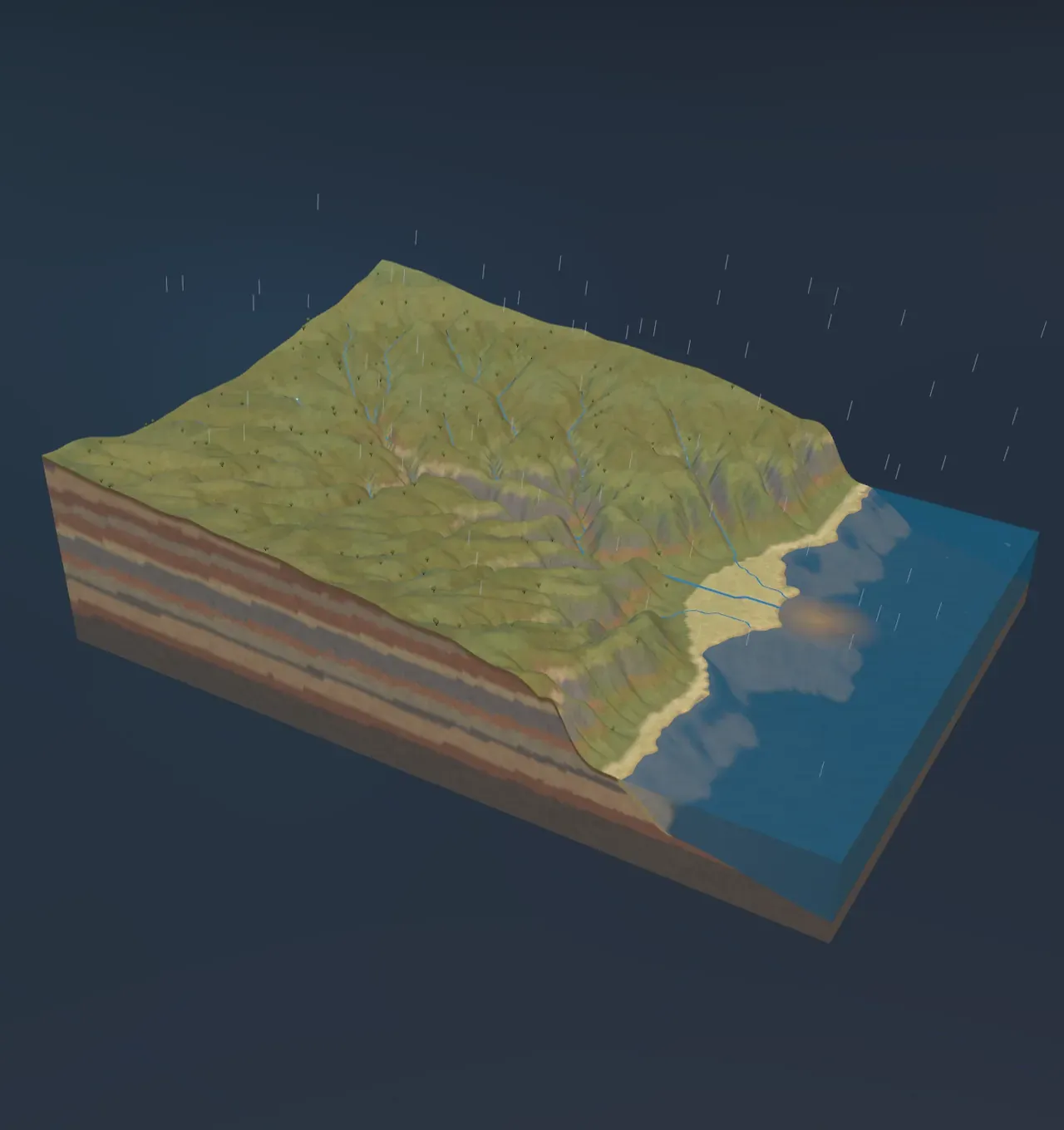
The Scene runs both for two million years over a young upland: a plateau of layered rock about 500 m high at its highest, ending at the sea in a low escarpment.
Weathering: rock breaks where it stands
Rock at the surface lives in conditions it was not made for. Water seeps into its cracks and freezes, and since water expands by about 9% as it turns to ice, every frost levers the cracks a little wider. Plant roots do the same more slowly. Salt crystals growing in pores, and rock heating by day and cooling by night, add their own small stresses. This is physical weathering: the rock breaks into smaller pieces that are still the same rock.
Chemical weathering changes the rock itself. Rainwater dissolves a little carbon dioxide from the air and from the soil, which makes it a weak acid. It dissolves limestone outright, which is how caves form, and it slowly turns the feldspar crystals in granite into clay, leaving the hard quartz grains behind as sand. Warmth and water speed it up, so rocks rot fastest in the wet tropics. The mix of broken rock, clay and the remains of living things that builds up on top is soil.
Soil does not stay put. It creeps downhill, a fraction of a millimetre a year, as it freezes and thaws, wets and dries, and is stirred by roots and burrowing animals. Where a slope is too steep for its soil to hold, the soil slides off and leaves bare rock behind, which weathers faster still.
Try it: look at the valley sides. On steep walls the beds of rock are bare, striped grey, red and buff; on gentler ground they are hidden under soil and plants. Choose Granite under Rock strength and the walls stand steeper and stay bare; choose Mudstone and they slump back to gentle slopes.
Rivers do the carving
Most of the work of moving rock is done by rivers. A river carries its load in three ways: dissolved in the water, as mud held up in it, and as sand and gravel rolled and bounced along its bed. The bouncing grains are its tools. They chip and grind the bed, and the river cuts down.
How fast it cuts depends on how much water flows and how steeply it falls. A river collects the rain of everything upstream, so it grows downstream, and a big river on a steep bed has the most power. The Scene uses a simple rule geologists call the stream power law: the river lowers its bed at a rate , where is the rainfall, the area of land the river drains, the slope of its bed and a number for how easily the rock wears.
A river cannot cut below the sea it flows into, so the sea is its base level. Near the coast, where the escarpment is steep, rivers cut fastest. Each valley deepens there first and then eats its way back into the upland, its head creeping inland and splitting into side valleys. The rivers organise themselves into a branching network, small streams joining bigger ones like the twigs of a tree. The valley sides weather, creep and slide into the river, which carries the rubble away, so the valley widens as it deepens.
Try it: slide Years slowly from Young upland. The first streams barely notch the plateau; the main river then cuts a deep valley back from the coast, and side valleys branch off it. In the chart, the blue river bed sinks below the dashed line of the young upland, deepest near the sea.
Rain and rock set the pace
In the stream power rule, the rain and the rock enter in different ways. More rain means more water in every river, but the power to cut grows only with the square root of the rain: four times the rain cuts about twice as fast. Weaker rock is easier to break, and the model makes its wearing simply inversely proportional to the rock’s strength, the pressure it takes to crush it. Mudstone crumbles under about 20 megapascals; good sandstone takes about 60; granite about 180.
After two million years under 800 mm of rain a year, the sandstone upland has lost about 5.8 cubic kilometres of rock, enough to lower the whole land by about 70 m on average. The same rain on mudstone wears away about 19 cubic kilometres, and on granite only about 1.5. Rain matters less than rock: going from desert to monsoon, 150 to 2,500 mm a year, raises the sandstone’s loss from about 2 to about 12 cubic kilometres, six times as much for seventeen times the rain.
Rock strength also shapes the valleys. Strong rock stands in steep walls and narrow gorges, while weak rock slumps back into broad valleys with gentle sides. So the same amount of time makes very different landscapes. A granite desert after two million years is lowered by less than 10 m on average, barely notched by its dry washes. Mudstone under monsoon rain is lowered by more than 250 m, its upland worn down to low, rounded hills.
Try it: choose Granite and Desert, then Mudstone and Monsoon, and scrub Years each time. Watch the volume worn away in the chart’s foot.
Real landscapes wear down at a few metres to a few hundred metres per million years. The fastest rates are in young mountains with heavy rain, such as the Himalaya and Taiwan; the slowest in old, dry, stable lands such as much of Australia.
Where the rock goes
Nothing that erodes disappears. Every grain the rivers carry goes somewhere, and on the way it is sorted by size. Big boulders move only in floods. Sand and gravel roll along the bed. The finest grains, clay and silt, stay held up in the water as mud.
When a river reaches the sea, its current spreads out and slows, and it can no longer carry its sand and gravel. They settle at the mouth and build out a fan of new land, flat on top and dropping in a steep front under the water: a delta. The river keeps flowing across its own delta to the front, so the delta grows outward. The mud mostly stays in the water and drifts out to sea as a brown cloud, to settle far from shore.
In the Scene, of the 5.8 cubic kilometres the sandstone upland loses in two million years, about 0.9 cubic kilometres of sand settle in the delta, building about 5 square kilometres of new land, and about 4.9 cubic kilometres of mud are carried out to sea. Weak rock breaks down to more mud, strong rock such as granite to more sand. Worldwide, rivers deliver around 20 billion tonnes of sediment to the sea every year. The Nile, the Mississippi and the Ganges and Brahmaputra, whose delta is the largest on Earth, have each built land the size of a small country.
Try it: watch the river mouth as you scrub Years. The sand fan pushes out into the water, the sea floor around it turns pale with settled sand, and the brown cloud of mud off the mouth grows when the river carries more.
The sand and mud do not stay loose forever. Buried under more layers, they are squeezed and cemented into new sandstone and mudstone, beds like the ones in the walls of the Scene’s valleys. That loop from rock to grains and back to rock is a story of its own, the rock cycle.
The long run
Left alone, erosion would wear any upland down to a low plain barely above sea level. Mountains still exist because the land is pushed up too: where tectonic plates collide, and where volcanoes pile up new rock. Every mountain range is a contest between uplift and erosion. The Colorado River has cut the Grand Canyon about 1.8 km deep, mostly in the last five or six million years, because the plateau it flows across has been rising.
The water that does all this work comes from the sea in the first place, lifted by the Sun and dropped as rain on high ground, as the water cycle shows. Rivers are not the only carvers. Wind scours deserts, waves cut back coasts, and in cold climates glaciers grind out wide, U-shaped valleys far deeper than rivers could.
What this model leaves out
The model wears down an upland that never rises, beside a sea that never changes level. Real sea levels have risen and fallen by over 100 m as ice ages came and went, drowning river mouths and stranding deltas. Its rain falls the same every year; real rivers do most of their work in rare floods, and a desert’s few storms carve more than its average rainfall suggests. Plants, which hold soil together and slow erosion, are drawn but not modelled.
The rivers follow a single steepest path from each 100 m cell, and they only cut: they never drop sand in their own valleys, build floodplains or wander from side to side. The delta is a simple fan of sand whose top sits just above sea level; real deltas split into many channels and are reshaped by waves and tides. The rock is one kind, equally strong everywhere, although the beds in the valley walls are coloured differently. Real landscapes are cut most deeply along their weakest beds and faults, leaving hard layers standing as cliffs and flat-topped hills. Finally, how fast a river cuts a rock of a given strength is a simple rule chosen for the model, good for comparisons but not for predicting any real valley.