The Christmas current
Fishermen on the coast of Peru have long known a warm current that arrives around Christmas and spoils the fishing for a few weeks. They called it El Niño, the Christ child. Every few years it comes early, stays for a year and runs far stronger. The cold, fish-rich water off Peru turns warm, the anchovies vanish, and storms pour rain onto one of the driest deserts on Earth. On the far side of the ocean, Indonesia and Australia go dry and forests burn.
Those far-apart events are one event. A century ago the British scientist Gilbert Walker found that air pressure across the tropical Pacific rises and falls like a seesaw: when it is high over Darwin in Australia it is low over Tahiti, and the other way round. He called it the Southern Oscillation. In 1969 the Norwegian meteorologist Jacob Bjerknes showed that the seesaw in the air and the warm water off Peru are two halves of the same loop between the wind and the sea. Scientists now call the whole thing ENSO, El Niño–Southern Oscillation.
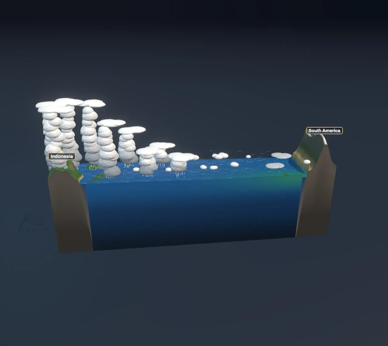
The Scene is a strip of the Pacific along the equator, 16,700 km from Indonesia on the left to South America on the right, cut open along the equator so you can see into the sea.
The trade winds pile up warm water
Near the equator the trade winds blow steadily from the east, air flowing towards the equator and turned westward by the spinning Earth, as The Coriolis effect explains. As they blow they drag the surface of the sea along with them, westward. The Sun warms that surface water all the way across, so by the time it reaches the western Pacific it is the warmest large body of sea water on Earth, about 29 °C. That is the warm pool. This westward current is the equatorial part of the wind-driven circulation described in Ocean currents.
The water piles up against Asia. In a normal year the sea’s surface off Indonesia stands about half a metre higher than off South America, and the warm layer is far thicker there. In the Scene, with trade winds of 5 m/s, the warm water reaches about 160 m down at 150° E but less than 60 m at 90° W. The slope of the sea pushes the warm water back east just as hard as the wind drags it west, which is why the tilt stops growing.
Try it: drag Trade winds slowly from Normal year down to zero. The sea’s surface flattens and the green, cold water off South America turns blue and warm, as the warm pool slides back east.
Cold water from below
Below the warm layer the ocean is cold. The boundary between them, where the temperature falls fast with depth, is the thermocline. A couple of hundred metres down the water is only about 11 to 15 °C, even on the equator.
The trade winds pull water up from there. Just off the equator the Coriolis effect turns the wind-driven current to the right north of the equator and to the left south of it, so the surface water spreads away from the equator on both sides, and water rises from below to take its place. That is upwelling. Where the thermocline is deep, as in the west, upwelling only stirs up more warm water. Where it is shallow, as in the east, it brings up cold water, rich in nutrients. Plankton thrive in it, anchovies eat the plankton, and the coast of Peru has one of the richest fisheries in the world. The westward current then carries the cooled water along the equator as a cold tongue.
Try it: step Show ocean and air to Ocean temperature. The water is coloured by temperature and the white line is the thermocline, deep under Indonesia and close to the surface off South America. The beads show cold water rising in the east and drifting west.
Rain follows the warm water
Over the warm pool the sea heats and moistens the air above it, and the air rises in towering thunderstorms; as in The water cycle, rising air cools and its vapour condenses and falls as rain. Indonesia gets about 10 mm of rain a day in the Scene’s normal year. The rising air spreads out high up, flows east, cools, and sinks over the cold water off South America, where it brings dry, clear air and only a low grey blanket of cloud; the coastal desert of Peru gets almost no rain at all. At the surface the air flows back west to the warm pool: the trade winds themselves. That loop is the Walker circulation, named after Gilbert Walker. Sinking air raises the pressure at the surface and rising air lowers it, which is the seesaw he found.
Try it: step Show ocean and air to Air loop. Air rises over the rain, crosses the ocean high up, sinks over the cool sea, and returns along the surface as the trade winds.
When the winds weaken
The loop feeds itself. The trade winds keep the east cold, the cold east keeps the air sinking there, and the sinking air drives the trade winds. If the winds slacken, the pile of warm water in the west is no longer held up. It slides back east along the equator as a long, slow bulge, a Kelvin wave, which takes two to three months to cross the ocean. When it arrives the thermocline off South America sinks, and upwelling there brings up only warm water. The east warms, the air over it starts to rise instead of sink, and the trade winds weaken further. The warmer the east gets, the weaker the winds become: a runaway that Bjerknes was the first to see.
That is El Niño. In the Scene, with the trade winds down to 2 m/s, the surface of the central Pacific warms by about 1.4 °C, the thermocline off South America sinks from about 60 m to over 110 m, and the sea’s half-metre slope almost disappears. The rain follows the warm water east: Indonesia’s rain is halved, and rain falls on the coast of Peru. Real El Niños also reach far beyond the Pacific, through changed winds high in the atmosphere, bringing drought to southern Africa and India and wet winters to the southern United States. With the ocean releasing so much heat, El Niño years are usually the warmest years on record (see Climate).
Try it: choose El Niño. Then step Show ocean and air to Air loop: the rising air has moved to the middle of the ocean, and a smaller loop over the west makes the air sink over Indonesia.
La Niña, and the swing between them
Push the winds the other way and the opposite happens. Stronger trade winds pile the warm water even higher in the west, raise the thermocline in the east right up near the surface, and make the cold tongue colder and longer. That is La Niña: wetter than usual in Indonesia and Australia, drier in Peru.
Weather services watch one stretch of the equator, from 170° W to 120° W, called Niño 3.4. When its surface is 0.5 °C or more warmer than normal for several months in a row, they declare an El Niño; 0.5 °C or more colder is La Niña. The Scene uses the same thresholds, against its own normal year: El Niño below about 4.3 m/s, La Niña above about 5.6 m/s.
Neither state lasts. An El Niño drains the warm water out of the western Pacific, and once it is spent the trade winds return, often overshooting into La Niña. The swing comes back every two to seven years, and each phase usually peaks around December and fades by the next summer. The strongest El Niños of recent decades came in 1982–83, 1997–98 and 2015–16.
Try it: choose La Niña and compare the chart with its dashed normal-year line: the east is colder, and the rain crowds into the far west.
What this model leaves out
The Scene shows the ocean once it has settled under a wind you choose. In the real Pacific nobody sets the wind: the winds and the sea steer each other, which is why El Niño grows, peaks and ends on its own, and why it takes months. The Scene leaves out that timing, the Kelvin and Rossby waves that carry the change, and the seasons.
The ocean is a single warm layer floating on cold water, its volume fixed, its thermocline tilted until the slope balances the wind’s drag. The wind is the same everywhere along the strip, though real trade winds are weaker over the warm pool and stronger in the east. How much upwelling cools the surface, how far the current carries the cold water, and how the rain is shared out by the warmth of the sea are rules of thumb calibrated to a normal year, so the numbers show the pattern, not a forecast. The strip shows only the equator and the sea north of it, while the coast of Peru lies south of the equator, and the rain over the ends is the rain of the nearest sea.