Snow that outlasts the summer
A glacier starts as snow that does not melt. Where more snow falls in winter than the summer can melt, a little is left each year. Buried under the next years’ snow, it is squeezed: the flakes round into grains, the grains weld into firn, and some tens of metres down the firn turns into solid glacial ice, with the old air trapped in it as bubbles. Thick glacier ice looks blue because ice absorbs a little of the red end of sunlight.
Glaciers come in three sizes. Valley glaciers fill mountain valleys, ice caps bury a highland, and ice sheets cover a continent. Only two ice sheets are left today, on Greenland and Antarctica, and between them they hold about two thirds of the world’s fresh water. During the ice ages, an ice sheet nearly as big as Antarctica’s covered most of Canada, and another covered northern Europe (see Ice ages and Milankovitch cycles). The Scene shows one of those: an ice sheet on a northern continent, cut through its summit.
Snow in, melt out
Every glacier keeps a budget. Up high, in the accumulation zone, snowfall wins and the ice gains mass. Lower down, in the ablation zone, the summer melts more than fell, and the ice loses it. The line between them, where a year’s snow and melt just balance, is the equilibrium line, which shows at the end of summer as the snow line. Air cools by about 6.5 °C for each kilometre you climb, so the high middle of an ice sheet stays below freezing all year while its low edges melt.
An ice sheet whose size holds steady loses as much as it gains. On land its edge stands where the melt eats up all the ice flowing out to it; where it reaches the sea, its surplus breaks off as icebergs. Warmer summers lift the equilibrium line, and the ice sheet shrinks until it balances again. More snow feeds it, and it spreads. In the Scene, the ice sheet takes the size that balances the climate you set.
Try it: slide Summer temperature from Ice age towards Today. The ice sheet shrinks, slowly at first. Past about 4 °C on the coast it cannot last at all: its surface sinks into warmer air as it thins, which makes it melt faster still. Then change Snowfall between 0.15 and 0.7 m/yr.
Snow and ice are the slowest part of the water cycle (see The water cycle): a snowflake that lands near the middle of an ice sheet can stay there for a hundred thousand years.
How solid ice flows
Ice is a solid, but under its own weight it creeps. Its crystals slide along layers inside them, slowly, like a very stiff putty. A pile of ice more than about fifty metres thick slumps outward, so an ice sheet spreads from its high middle, the ice divide, towards its edges, pushed by the slope of its own surface.
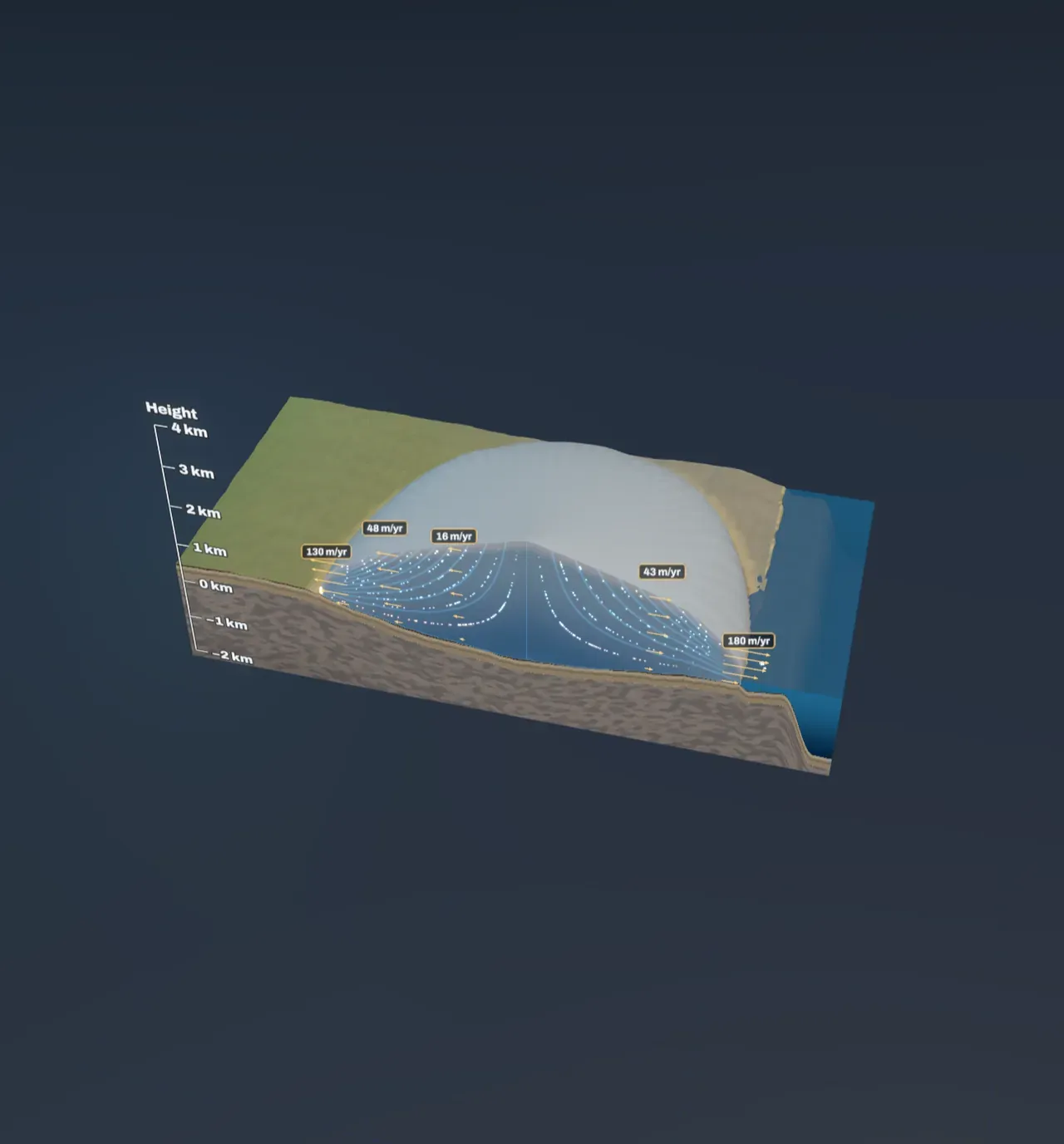
The ice moves fastest at the top and slowest at the bottom, because each layer slides over the one beneath it and the bottom layer is held back by the ground. Where meltwater gets under the ice, it slides over its bed as well. Near the divide the ice barely moves, a few metres a year. Towards the edges, where all the snow from upstream has to pass, it flows a hundred metres a year or more, and in fast ice streams several kilometres.
Snow that falls near the divide is buried by the snow that falls on top of it and sinks deep into the ice, then travels slowly outward along the bottom for a hundred thousand years or more. Snow that falls nearer the edge stays near the surface and comes out quickly. So the oldest ice lies deep under the middle of an ice sheet, which is where ice cores are drilled: one from Antarctica holds bubbles of air about 800,000 years old.
Try it: step Look under the ice to Flow inside. The arrows give the speed at five depths in a few places; the dots are parcels of snow following the ice, white when freshly fallen, blue after thousands of years and amber after tens of thousands. On the left they come back to the surface in the ablation zone and melt; on the right they reach the sea in icebergs.
The ice also carries rock. Stones frozen into its base scrape and grind the bed as it slides, and the ice plucks loose blocks away. That is how glaciers carved the U-shaped valleys of the Alps, the fjords of Norway and the hollows that now hold the lakes of Canada and Finland.
The ground sinks under the ice
The Earth’s crust floats on the mantle beneath it, which, over thousands of years, flows like a very thick fluid (see Plate tectonics). Load the crust with three kilometres of ice and it sinks, as a boat settles when it is loaded, until the mantle it pushed aside weighs as much as the ice. Ice is a little more than a quarter as dense as the mantle, so the ground ends up pushed down by about a quarter of its thickness. Under the middle of a big ice sheet the bed sinks below sea level.
Try it: step Look under the ice to Under the ice. The dashed line is where the ground would be with no ice on it. The crust is stiff, so it bends over a wide area rather than just under the ice.
When the ice melts, the ground rises again, but slowly, because the mantle has to flow back. The ice sheets of the last ice age melted away between about 15,000 and 7,000 years ago, and the land beneath them is still rising: around Hudson Bay and the Gulf of Bothnia by about a centimetre a year. Old beaches that were at sea level when the ice left now stand tens to hundreds of metres up the hillsides.
Ice on land is water missing from the sea
Every tonne of ice on land is a tonne of water taken from the sea. At the height of the last ice age, about 20,000 years ago, the sea was some 120 m lower than today. A dry land bridge joined Siberia to Alaska, and Britain was joined to Europe. The ice sheet in the Scene on its own holds enough to lower the sea by about 15 m at the starting setting; the chart beside the Scene shows how much it takes away for every summer temperature.
Today the sea is rising by about 4 mm a year, roughly half of it from melting glaciers and ice sheets and most of the rest because sea water expands as it warms (see Climate). If all of Greenland’s ice melted, the sea would rise about 7 m; Antarctica’s would add about 58 m. Sea ice and the ice shelves that float at the edge of Antarctica are different: floating ice already displaces its own weight of water, so melting it barely changes the sea level, although losing the shelves lets the ice behind them flow into the sea faster.
What this model leaves out
The ice sheet is drawn with the simplest shape glaciologists use, a dome just thick enough to press on its bed with a fixed force, and its flow is worked out from where snow falls and melts, assuming the ice sheet has settled to a steady size. A real ice sheet takes thousands of years to adjust after the climate changes, so none is quite in balance. Real ice sheets also have fast ice streams, floating ice shelves, mountains and valleys under them, and a climate that varies from place to place; here the summers just warm smoothly to the south and cool with height, and less snow falls on high ice, where the air is cold and dry.
The model shows the ice sheet a climate keeps, starting from a big one and letting it shrink. Starting from bare ground, the same climate might never grow one: an ice sheet that already exists keeps its surface high and cold, so it can survive summers in which a new one could not start. The ground is shown fully settled under the ice. The sea-level figure treats the ice sheet as a dome 1.4 times longer than it is wide, and ignores ice resting below sea level, which would not raise the sea if it melted. Glacial erosion is not shown.