Weather is air on the move
Almost all weather happens in the lowest 10 to 15 km of the atmosphere, the troposphere described in Layers of the atmosphere. Two things drive it. The Sun heats the ground far more than it heats the air, so the air is warmed from below. And air holds water vapour, which takes up and gives back a great deal of heat as it evaporates and condenses.
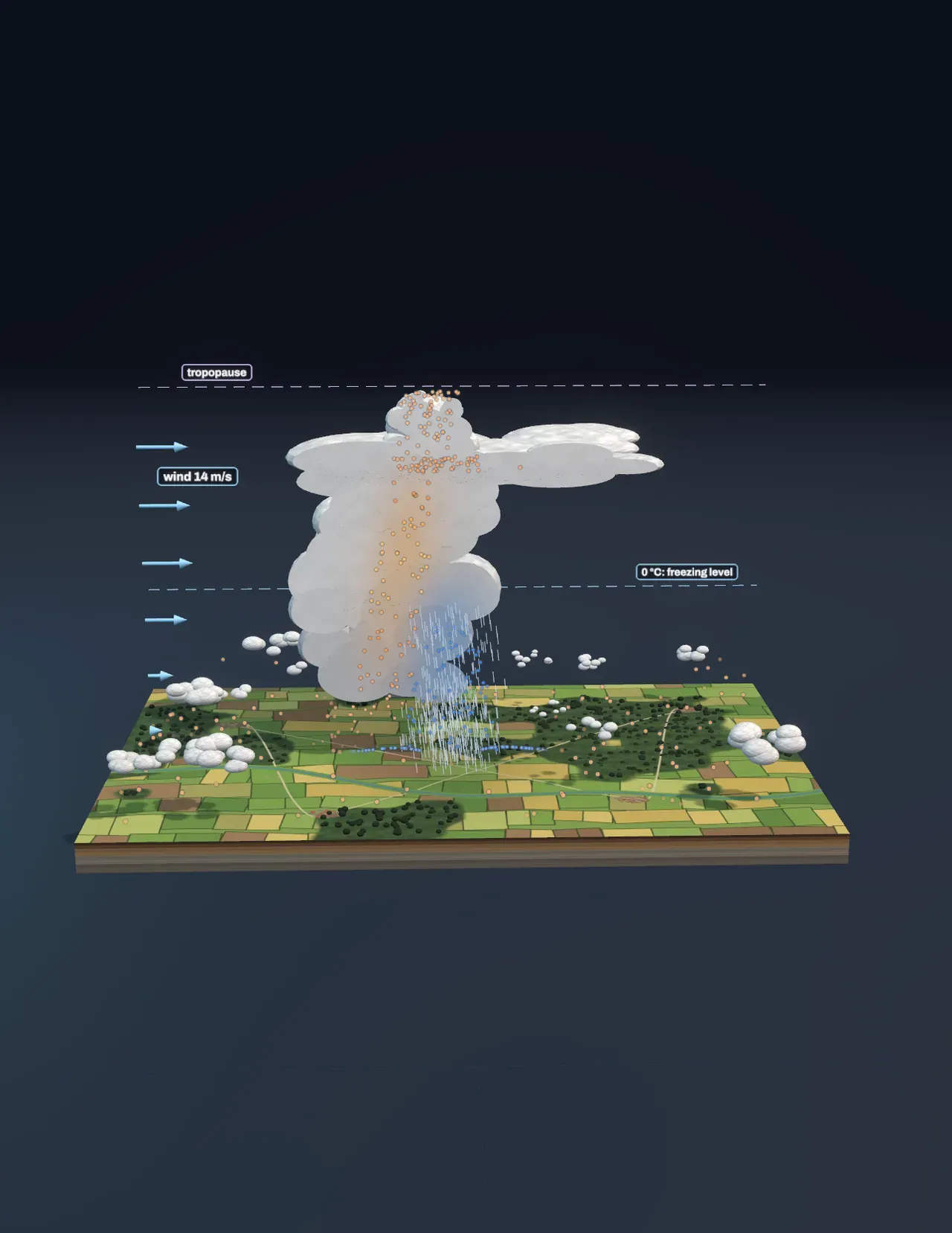
Warm air from the ground rises, cools and comes down again somewhere else. That loop is a convection cell, the same motion as water in a pan on a stove. On a summer afternoon convection can make anything from a clear blue sky to a thunderstorm 13 km tall. The Scene shows which one you get, on one block of farmland, from three things: how warm the ground makes the air, how much vapour that air carries, and how the wind changes with height.
Why warm air rises
Sunlit fields, roads and roofs heat the air touching them. A bubble of that air, a thermal, is lighter than the cooler air around it, so it floats up, the way glider pilots and soaring birds ride them. As it rises the pressure on it falls, so it expands, and expanding air cools: by 9.8 °C for every kilometre it climbs, whatever the weather. Meteorologists call this the dry adiabatic rate.
Whether the thermal keeps going depends on the air it rises through. In the Scene the air aloft is fixed: it is 6.5 °C colder each kilometre up. A thermal cools faster than that, so it would soon be as cold as its surroundings and stop, unless the ground keeps warming the lowest air. On a hot afternoon thermals stir the lowest one or two kilometres until that whole layer falls off at the dry rate. The hotter the ground under the same air aloft, the steeper the fall of temperature with height, and the more readily air rises. This temperature gradient is the first ingredient of a storm.
Try it: slide Ground temperature to 20 °C, then up to 33 °C. At 20 °C the ground is no warmer than the air above it and the thermals stop about 200 m up. At 33 °C the air over the lowest 3 km cools by 8.7 °C per kilometre, and the chart shows the amber line of the rising air running to the right of the black line of its surroundings: warmer, so still rising.
Cloud base: where a thermal reaches its dew point
Every thermal carries the vapour of the air it left. Its dew point is the temperature at which that vapour would start to condense. As the thermal rises and cools, its temperature closes on its dew point by about 8 °C every kilometre, so it reaches it at a height of about 125 m for every degree between the two at the ground. There the vapour condenses into droplets and a cloud begins. Every thermal reaches that height at once, which is why cumulus clouds have flat bases all at one level.
Dry air needs a long climb. On a hot day with a dew point of 5 °C the thermals would have to reach about 3.5 km to make cloud, and in the Scene they stop at 3.1 km: hot, bumpy, cloudless air, as over a desert. Humid air reaches its dew point low down.
Try it: set Ground temperature to 33 °C and Dew point to 5 °C: the thermals rise high and leave the sky clear. Now raise Dew point to 21 °C: the cloud base drops to 1.6 km and the cloud races upwards.
The fuel: heat from condensing vapour
It takes about 2.5 million joules to evaporate a kilogram of water, energy that came from the Sun at the sea or a wet field. When the vapour condenses in the cloud, all of that heat comes back. So cloudy air cools much more slowly as it rises, about 4 to 7 °C per kilometre instead of 9.8, and can stay warmer than the air around it all the way up. That latent heat is what turns a small cumulus into a thunderstorm. In the cut-open cloud, the amber of the updraft brightens from the cloud base upwards: the brighter, the more the condensing vapour has warmed the rising air above its surroundings.
Forecasters measure that fuel as CAPE, the energy each kilogram of rising cloudy air gains from being lighter than its surroundings: the amber area in the chart. With the Scene’s starting afternoon, 31 °C with a dew point of 18 °C, it is about 1,350 J/kg. If all of it became speed the air would reach √(2 × CAPE), about 52 m/s; drag, mixing and the weight of the rain hold real updrafts to about half that, here 26 m/s, close to 100 km/h straight up.
Try it: step Build the storm to Cumulus and then Towering, and watch the beads speed up and brighten as they pass the cloud base. With a 21 °C dew point the CAPE grows to about 3,400 J/kg and the updraft to about 41 m/s.
The cap: fair-weather cumulus
The air aloft in the Scene has a slightly warmer layer between 1.8 and 2.1 km, a capping inversion, as real air often has. A cloud that reaches it is suddenly colder than its surroundings and stops. With the ground at 24 °C and a dew point of 18 °C the cloud base is at 840 m and the cumulus stop at about 3 km: the scattered white puffs of a fine summer day. Only when the ground is hot enough, or the air moist enough, does rising cloudy air punch through the cap, and then nothing stops it until the tropopause.
The anvil, the rain and the downdraft
The tropopause, about 12 km up in the Scene, is the floor of the stratosphere, where the air stops getting colder with height. The updraft runs out of buoyancy just below it and spreads sideways as a flat anvil, carried downwind by the strong winds up there; the fastest air overshoots a little and falls back. A thunderstorm’s top is colder than −40 °C.
Above the freezing level, here about 4 km, the cloud is a mix of supercooled droplets, ice crystals and soft hail. They grow quickly and fall. Collisions between ice crystals and soft hail separate electric charge, the same kind of charging described in Static electricity, until the field is strong enough for lightning, and the heated air of each flash expands with the crack of thunder. Falling rain and hail drag air down with them, and the rain that evaporates on the way cools it further, so a cold downdraft pours out of the cloud’s base and spreads along the ground as a gust front: the sudden cold wind before a summer storm.
Why wind shear decides a storm’s life
Wind shear is how much the wind changes with height. In the Scene it is the difference between the wind at the ground and the wind 6 km up, shown by the arrows at the left.
With little shear, under 10 m/s, the updraft stands straight. Its rain falls back down through it, the cold downdraft chokes the rising warm air, and the storm rains itself out in under an hour: a single cell, the classic afternoon thunderstorm. With moderate shear, 10 to 20 m/s, the gust front runs ahead of the storm and lifts warm air at its edge into new cells, so a cluster, a multicell, keeps renewing itself for hours while each cell lives and dies. With strong shear, over about 20 m/s, and plenty of CAPE, the updraft leans over so its rain falls beside it rather than into it, and the shear sets the updraft spinning: a supercell, which can last for hours and bring large hail and tornadoes.
Try it: step Build the storm to An hour on and slide Wind shear between 0, 14 and 25 m/s. With none, the tower has slumped into ragged remnants under the anvil, raining lightly into its own cold air. With moderate shear a new cell stands where the gust front lifted the warm air. With strong shear the tilted, turning updraft is still going, with a lowered wall cloud under it.
From storms to weather
A thunderstorm is weather at its smallest scale: a few kilometres across, an hour or two long. At any moment about 2,000 of them are rumbling around the world, and the planet’s lightning flashes about 45 times a second. The same ingredients, unstable air, moisture and something to lift it, also work at much larger scales. Where a mass of cold air pushes under warm air, along a cold front, it lifts the warm air like a wedge and can set off a line of storms hundreds of kilometres long. Where warm air rides gently up over cold air, at a warm front, it makes wide sheets of cloud and steady rain. Fronts wrap around low-pressure systems that turn because of the Earth’s rotation, as explained in The Coriolis effect.
Mountains lift air too, which is how the slopes in The water cycle get their rain. Ocean temperatures shift where storms form from year to year, as in El Niño. And a warmer climate puts more vapour into the air, about 7% for each degree, so the heaviest downpours carry more water (see Climate).
What this model leaves out
The Scene uses parcel theory: each thermal rises as one bubble that never mixes with the air around it. Real updrafts draw in drier air from their sides, which weakens them, and the water they carry weighs them down; the Scene allows for both only by quoting the updraft at half its parcel-theory speed. The air aloft is one fixed profile, with no change through the day, no winds that turn with height and no sea breeze or hills to lift the air. The storm types follow simple thresholds of shear and CAPE that forecasters use as rules of thumb, not a simulation of the storm’s winds.
The storm’s life is a sequence of drawings, not a weather model: the stages are the ones storms go through, but their timing, the shapes of the clouds and the amount of rain are illustrative. Lightning flashes far more often than real storms manage, beads, rain and lightning are drawn far larger than life, and the cloud is cut in half only to show what no one could see from outside.